
Rigets Hovedstrøg
The road that connected eastern and western Denmark through centuries
Rigets Hovedstrøg is the historic route that connected eastern and western Denmark for centuries. Travellers crossing the country, from as far as the 16th century until the 1930s, used this route when they needed to cross the Great Belt. It was also the route the king used when arriving in Nyborg. The road led through the heart of the town and directly past the impressive castle, where kings and queens once resided and from where important decisions about the Danish realm were made.
How can you tell when you are on Rigets Hovedstrøg?
The route that makes up Rigets Hovedstrøg begins (or ends) at Kongens Skibsbro by the harbour. From there it continues up Adelgade, before turning left at Vor Frue Church and continuing down Kongegade. At the end of Kongegade, you can either continue straight ahead or turn right onto Korsgade. If you continue straight along Kongegade, you will reach the small square in front of Borgmestergården (today a museum), from where it is impossible to miss the royal castle. If you instead take the route along Korsgade, you will cross the town square (Christian III’s former tournament ground), pass by the castle, and the reach Stendamsgade, continuing through the land gate and on to Lindealléen.
Bronze tiles mark the historic route
Along Rigets hovedstrøg, thousands of travellers have left their traces, whether moving from east to west or the other way around, on foot, on horseback, by carriage, or later by car. For this reason, bronze tiles with different motifs have been installed to tell the stories of the events connected to the town and its history. The route from Kongens Skibsbro to Ravelinsvej is approximately 1 km long. Tiles have been placed every four metres in fixed rhythm, alternating between icon tiles, motif tiles, and large overview maps. Together, the tiles create a guiding thread through Nyborg and make Rigets Hovedstrøg visible throughout the town.
1. Icon tiles
The icon tiles are the smallest (9×9 cm – the size of cobblestones) and feature three recurring motifs. They are placed along the entire route in the middle of the pavement. The motifs are: a wheel icon; symbolising movement and transport, the lion and heart icon, and Erik Klipping’s open crown. In total, there are 154 icon tiles.

Icon tile – Wheel
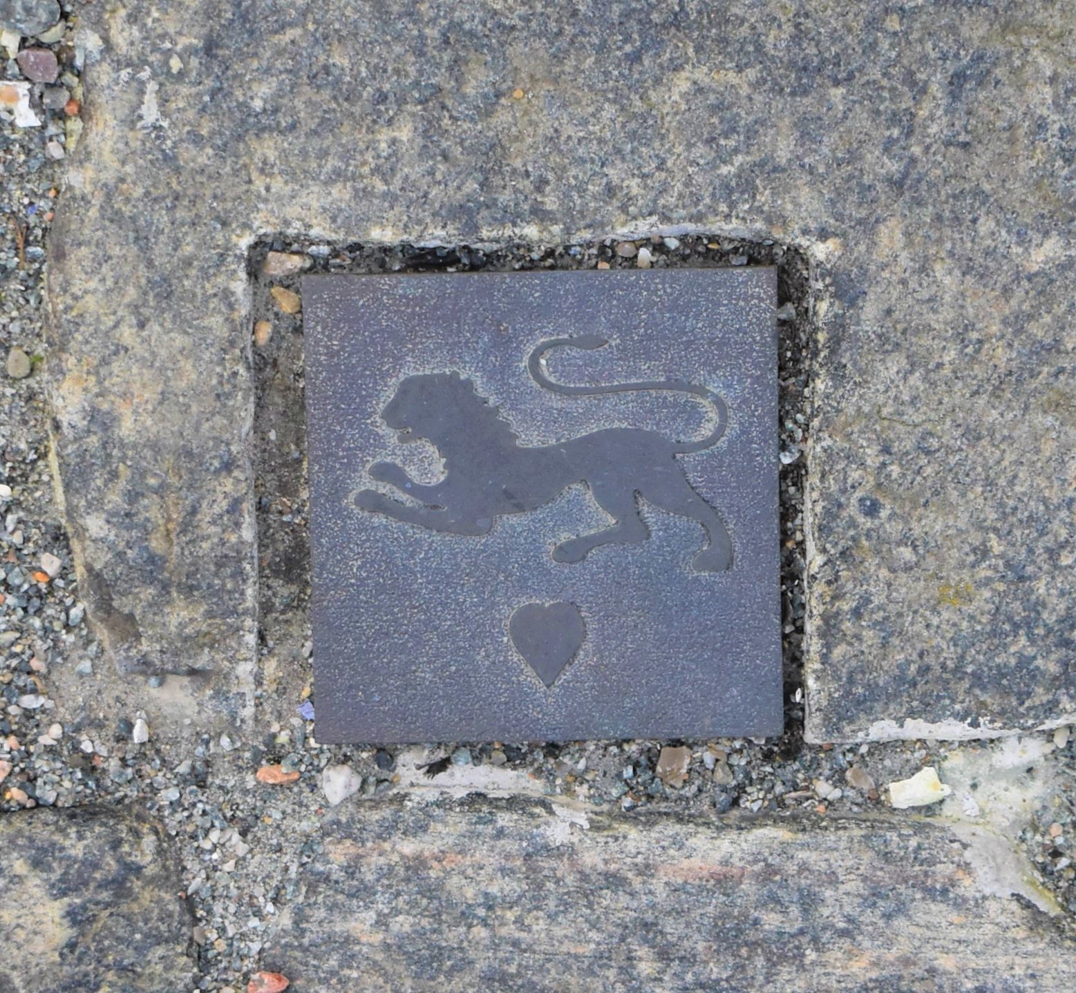
Icon tile – Lion and heart

Icon tile – Crown
2. Motif tiles
A series of larger tiles (30x 30 cm) depicts different forms of transport from the middle ages up to 1935, when the route ceased to have its important function. The means of transport range from a bicycle and a car to a knight on horseback, a ship, and more. The tiles also tell the story of the many people who have been part of Rigets Hovedstrøg. From farmers and townspeople to soldiers and royalty. The placement of the different motifs along the route depends on the particular story being told. Near the church, visitors can also see motifs related to the church, such as Christian III’s bible and a bride and groom. In total, there are 23 different motifs distributed across 48 tiles.

Motif tile – Man pulling a cow

Motif tile – Bride and groom by the church

Motif tile – Ferry by the harbour

Motif tile – Soldiers
3. Overview maps
Last but not least, ten large overview maps (Ø 100 cm) have been created for key points along the route. A marker on the map shows where you are located along the route. The overview maps are based on Niels Høirup’s map of Nyborg, depicting the town as it appeared around 1810, when the fortress was at its greatest extent.

Historic photographs behind several motifs
The motifs for the bronze tiles were designed and developed by architect mAA Anne Mette Rasmussen from D-sign Tegnestuen. They were cast at skulpturstøberiet in Svendborg. Birkely Anlægsgartner carried out the installation of the bronze tiles and maps along the route through the streets.
Anne Mette Rasmussen found many of her motifs on arkiv.dk, and wherever possible chose motifs connected to Nyborg. The motifs were then simplified and redrawn as line drawings that could be transferred to MDF boards using a laser cutter.
Anne Mette describes one of her motifs – the man with the suitcase – as follows: “The model for ‘the man with the suitcase’ is a photograph from arkiv.dk. I chose this particular motif for one of the bronze tiles because it is both expressive and simple, making it well suited as a line drawing. The man’s expression is one of waiting, perhaps even expectation? I imagine that he is standing at the ferry landing in Nyborg after walking along ‘Rigets Hovedstrøg’, waiting to sail on the ferry Heimdal to Korsør in the early 1930’s.”
Learn more about the history
In connection with the story of Rigets Hovedstrøg, information posts have been developed and placed at strategic locations throughout the town. The signs are in the same colour as Nyborg’s city maps, and the posts are made of metal and decorated with a wheel from the wheel icon. The information posts are presented in both Danish and English and share the history of this important route with both residents and visitors.


Worth knowing about Nyborg Castle
The oldest part of Nyborg Castle dates back to around year 1200. Over time, the castle was expanded by the monarchy into a large brick ring wall castle. It was here that the Danish parliament, the Danehof, met, and where Denmark’s first constitution, the Charter of 1282, was signed in the Danehof Hall. In the first half of the 16th century, Nyborg Castle and the town were transformed into a princely showpiece and a planned residence town for the Danish king. Nyborg Castle served as the royal residence in the country’s first true capital until the monarchy moved to North Zealand after 1560. In the centuries that followed, the ravages of time took their toll on the castle, until an incomplete restoration saved the buildings in the early 20th century.
Read more about Nyborg Castle
Rigets Hovedstrøg is a part of the Castle Project – the redevelopment of Nyborg Castle and town
For 700 years, Nyborg was not only situated along the country’s central east-west route, but traffic was also directed through the town’s gates so that the fortress could function as a lock, controlling all passage across the realm. Through the town – between the Beach Gate and the Land Gate – ran Rigets Hovedstrøg, the main route of the realm. The route passed directly by the castle and across the tournament ground as a clear symbol of the king’s control over movement and the kingdom. The Land Gate, the longest fortress gate in the Nordic countries, still stands today, and the echo of centuries of passage by both known and unknown Danes can still be heard beneath its vault.
